Asian Textile Studies
Contents
Solor Island 1
Introduction
Geography
Economy
Pre-History
Early History
The Portuguese on Solor
Arrival of the Dutch
Solor Island 2
Departure of the Dutch
Solor Alone
Nineteenth Century Solor
Solor becomes a Dutch Possession
Twentieth Century Solor
Bibliography
Introduction
The small rugged volcanic island of Solor is extremely undeveloped and only lightly inhabited. Its small population of 36,000 are ethnically Lamaholot, with almost 60% classified as very poor. The western half of the island is mainly Catholic while the eastern half is mainly Muslim.
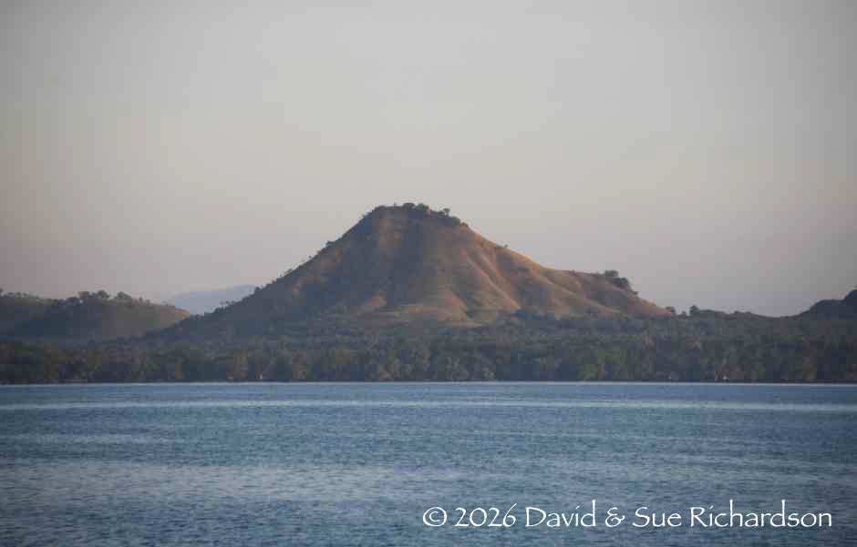
Above: A view of the coast of northern Solor from the Solor Strait.
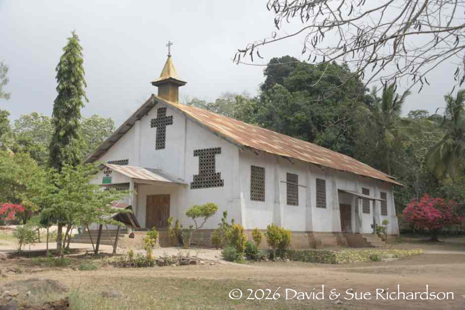
Below: The Catholic church of Kristus Raja in Lamaole, southwest Solor.
Though hard to believe today, in the mid-sixteenth century Solor Island became the base for the colonial control of the eastern Lesser Sunda Islands for roughly 100 years, initially occupied by the Portuguese and later by the Dutch.
Today the island is politically part of East Flores Regency, governed from Larantuka. Neglected as a backwater for many decades, the island has more recently benefitted from some modern road construction.
Return to Top
Geography
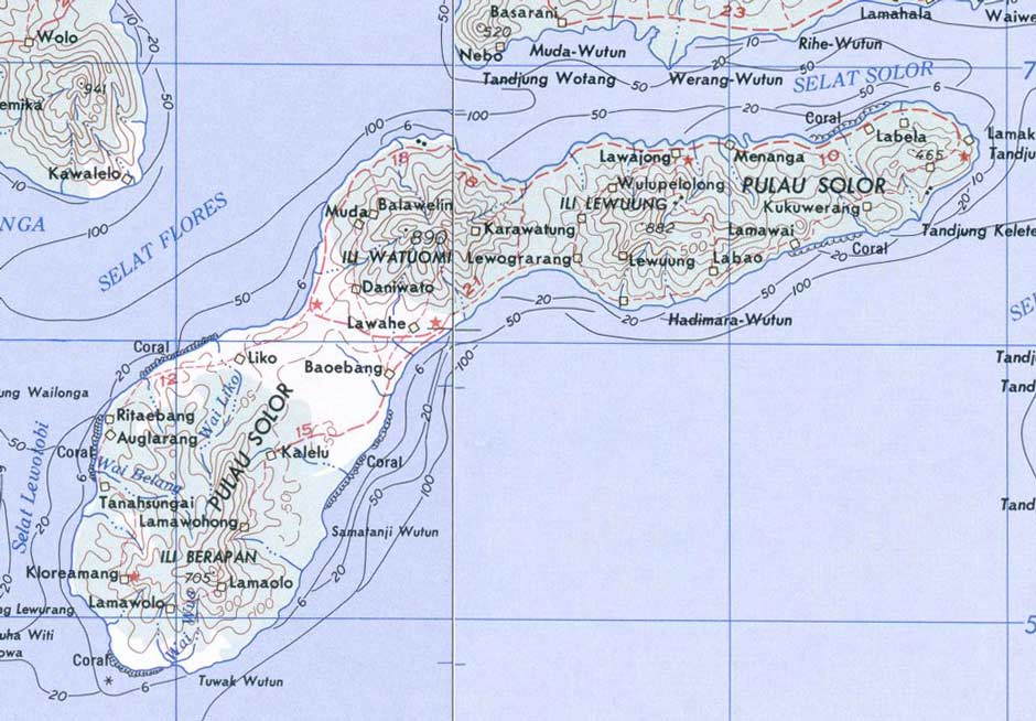
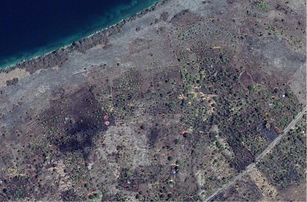
Boomerang-shaped Solor Island is just 31km from west to east and no more than 9km wide. To the north the narrow Solor Strait separates it from Adonara while to the west the powerfully tidal Flores or Loba Tobi Strait separates it from East Flores. The Savu Sea lays to the south.
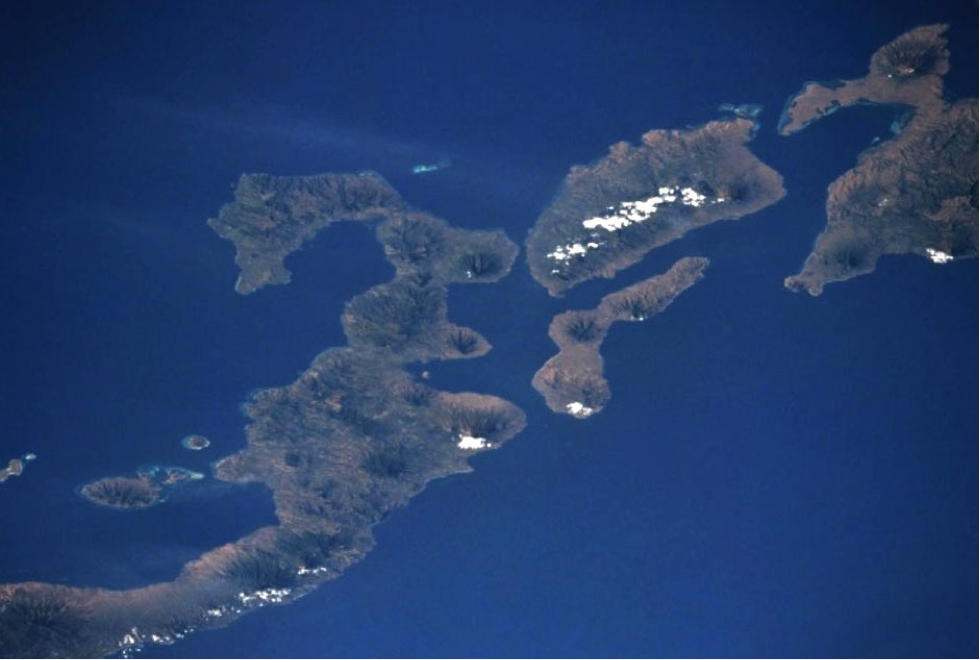
Solor Island is positioned just south of Adonara and is flanked in the west by East Flores and in the east by Lembata.
Image courtesy of NASA Johnson Space Centre, July 1994.
Volcanic in origin, Solor Island shares an identical geology to that of southern Lembata (De Jong 1941, 133). Its wild and beautiful landscape is segmented by lowlands that stretch from the north coast to the south coast, dividing the island into four highland regions. These are dominated by three small partially forested mountains, Ilé Berabun (697m) at the western extreme, Ilé Niu (865m) in the centre, and Ilé Napo (845m) just to the east, while a cluster of lesser mounts occupy the far eastern peninsula. The dry surrounding lowlands are sparsely covered with savannah scrub and scattered trees.
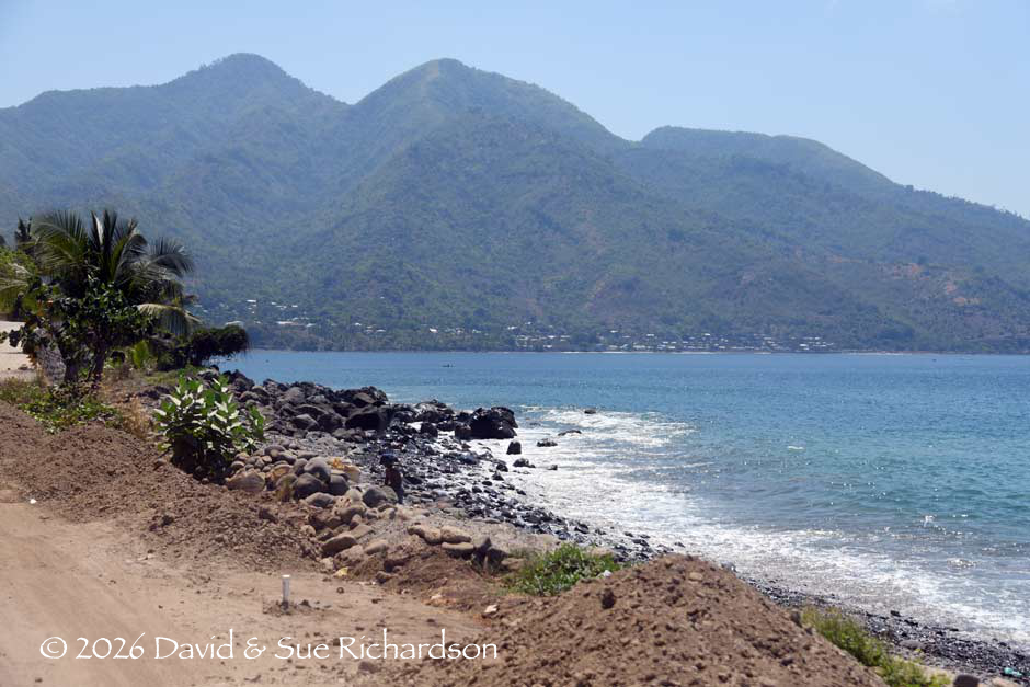
The coasts of Solor are mainly low sandy or stony beaches, occasionally backed by cliffs. There are numerous safe anchorages, especially at Pamakayo, Lohayong, Menanga and Labala.
A military map of Solor Island. Many of the hills and villages are incorrectly named.
US Army, Washington D. C., 1963.
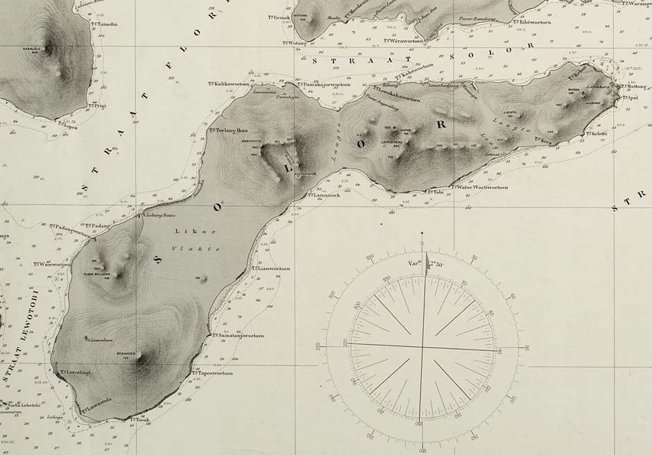
The topography of Solor Island from a nautical chart of 1911
Solor experiences a long dry season lasting from early April until December. The wettest month is January. The hottest month is October, when the average temperature is 25°C, and the coldest is February, with 22°C.
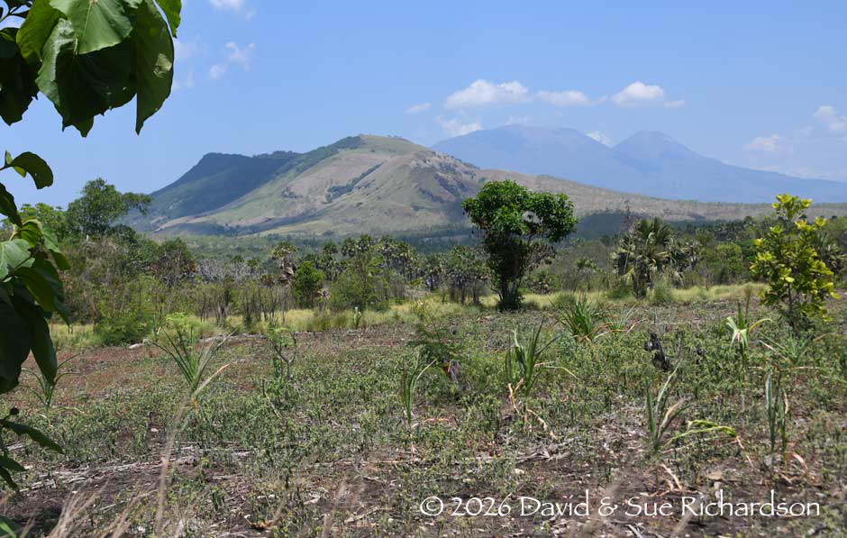
Looking east towards the twin peaks of Ilé Niu and Ilé Nome, with Ilé Napo beyond and the peak of Ilé Boleng on Adonara in the distance
Looking east across Kelike Bay towards the hamlets of Watanhura I and II and Ilé Napo
The population of Solor Island in 2023/24 was 36,176, skewed 50.8% female and 49.2% male. By district:
| 2023/24 | Males | Females | Total |
| Solor Timur 2023 | 8,440 | 8,626 | 17,066 |
| Solor Barat 2024 | 5,719 | 5,995> | 11,714 |
| Solor Selatan 2024 | 3,634 | 3,762 | 7,396 |
| Total | 17,793 | 18,383 | 36,176 |
Sources: Kecamatan Solor Timur Dalam Anka 2024,
Kecamatan Solor Barat Dalam Anka 2025,
Kecamatan Solor Selatan Dalam Anka 2025,
Badan Pusat Statistik Kabupaten Flores Timur.
Most of the villages are located around the coast or in the low-lying areas between the hills. Generally, the western part of Solor is Catholic while the eastern part is Muslim.
Politically Solor is one of the two main islands of East Flores Regency, the other being Adonara. Solor has been traditionally divided between east and west but since December 2010 it has been subdivided into three districts – Solor Barat with its administrative centre in Ritaebang, the island’s main town; Solor Selatan administered from Kalike; and Solor Timur administered from Menanga. Ferries from Larantuka service the ports of Ritaebang, Pamakayo and Podor. Ferries from Waiwerang on Adonara Island go to Menanga, Lahayong and Lamakera.
Return to Top
Economy
Solor is a poor, highly undeveloped island with very limited resources. A 2016 survey classified 15,560 residents on Solor (57% of the population) as poor or very poor, having the lowest welfare standards.
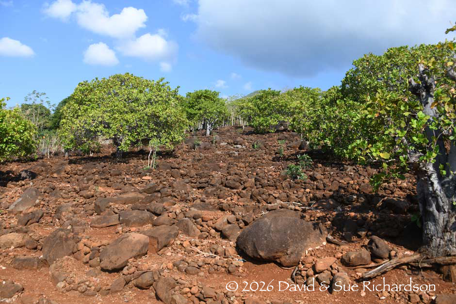
Agriculture is heavily constrained by the incredibly stony volcanic landscape. Much of the land is infertile apart from some of the villages in West Solor who receive water through pipelines (Kroon 2016, 6). Here many villages have landscaped the hillsides with huge numbers of narrow stone terraces. Clean water is relatively limited and the island is prone to drought. To make matters worse, many farmers are not landowners and gain access to land in return for loans to their landlords. This means that their farmed land cannot be passed on to their children.
Above: Stone terraces on the west coast just south of Nusa Dani.
Below: Stone terraces close to Balaweling
The majority of the population are farmers who mainly grow corn, cassava, rice and cashew nuts. Some 60% of useable land on Solor is used for growing cashew nuts, the island’s main cash crop, and of the remainder around 33% is used for growing corn.
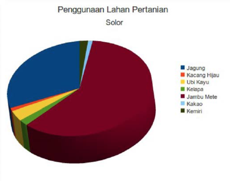
Agricultural land use on Solor in 2006.
(Status Pemenuhan Kak Desar di Pulau Adonara dan Solor 2010)
Crop area and production
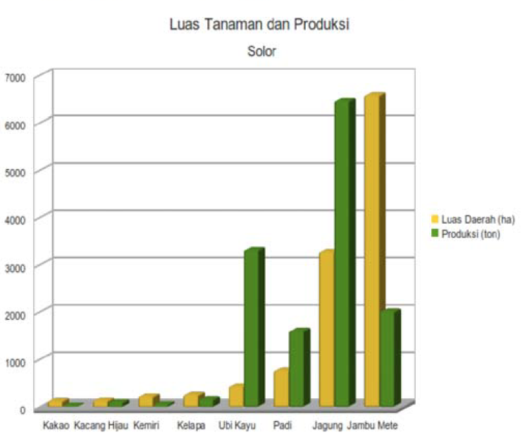
By tonnage, the dominant crop is corn (jagung), followed by cassava (ubi kayu), cashew nuts (jambu mete) and padi rice.
A few fishermen operate from villages along the north and south coasts. Lamakera on the eastern tip of Solor was one of the world’s top manta ray hunting sites – previously landing around 1,500 mantas in a single season (Dewar 2002). In 2014, this small fishing village, and indeed all of Indonesia, was declared a manta sanctuary.
Pre-History
Surprisingly we know very little about the origin of the Lamaholot people, who occupy the neighbouring islands of Solor, Adonara and Lembata as well as the eastern tip of Flores. Their Lamaholot language contains features that indicate Papuan influence, suggesting a prehistoric Papuan presence in the Lamaholot homeland (Klamer 2012, 72). This is far from surprising – it is possible the first Melanesians began migrating from Southeast Asia (Sundaland) to the continent of Sahul (New Guinea plus Australia) as early as 65,000 years ago. However, when and how Austronesian-speaking immigrants arrived in this region is still far from clear – archaeological evidence suggests that Austronesian reached eastern Indonesia around 2000 to 1500 BCE (Bellwood 1997; Spriggs 2003).
A population genetics study in 2012 compared simple genetic mutations (single nucleotide polymorphisms or SNPs) across 13 Austronesian populations from Sumatra to Alor, including the western Lamaholot, the Lamaholot from Lembata and the closely related Alorese from Alor (Xu et al 2012).
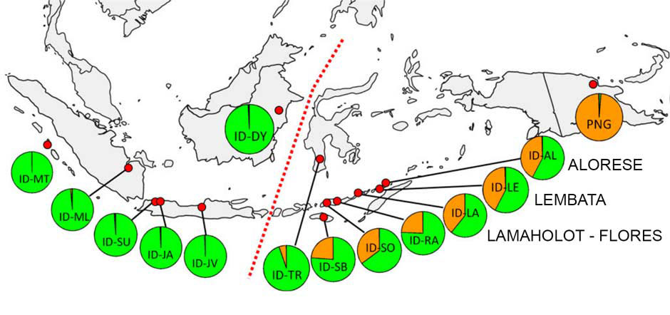
Geographical distribution of Austronesian (green) and Papuan (orange) admixtures. The Wallace Line is in red (Xu, Pugach, Stoneking, Kayser, Jin and the HUGO Consortium 2012)
Its findings showed that western populations had a predominantly Asian ancestry, whereas beyond the Wallace Line there was a progressive change in admixture with an increasing Melanesian content moving eastwards towards New Guinea. Furthermore, there was a cline of decreasing time of admixture along the Malay Archipelago, with the oldest time in the west and youngest time in the east. It suggests a spread of individuals of Asian ancestry coming from the west and admixing with resident groups of Papuan ancestry. Two different calculations showed consistent results regarding the time of admixture, which was estimated to have begun about 4,000 years ago, consistent with archaeological findings.
A 2014 population genetics study compared the SNPs of 56 Southeast Asian populations, 31 of which were Austronesian-speakers (Lipson et al 2014). The latter again included the western Lamaholot, the Lamaholot from Lembata and the Alorese from Alor. These three closely related populations had a simple admixture of Melanesian (Papuan) and Austronesian genes with no contribution from Philippine Negritos or from the Austro-Asiatic mainland. These findings pointed to a migration out of China/Taiwan that by-passed the Philippines and progressed down the Malay Archipelago from west to east, consistent with the 2012 study.
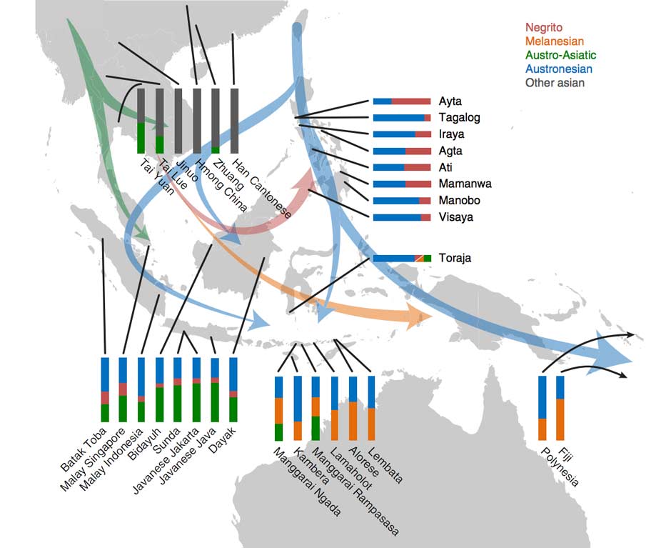
The possible directions of human migrations into Indonesia
(Lipson, Loh, Patterson, Moorjani, Ko, Stoneking, Berger and Reich 2014)
The study attempted to genetically compute when the admixture in eastern Indonesia took place, assuming a single wave of immigration. It found that it occurred just 30 to 65 generations ago, equivalent to 900 to 1,800 years ago assuming 29 years per generation. The researchers assume that these reflect additional waves of interaction long after the initial wave of Austronesian settlement.
These studies suggest that the Solor Islands were initially occupied by Austronesian-speakers migrating from the west – in other words from Flores. This would explain the close links between Lamaholot and the neighbouring languages of Sikka to the west on Flores and Kedang on Lembata to the east (Keraf 1978).
Of course, the Solor Islands are not only located at a strategic point along the island chain but also on an important sea route. For millennia, the Larantuka Channel between East Flores and Adonara Island has offered seafarers a link between West Timor and Sulawesi and Maluku. Whilst the Larantuka Channel is affected by strong tidal currents, it provides access to the calm protected waters of the Flores Strait, sheltered on all sides by the islands of Flores, Adonara and Solor.
Despite this it is possible that during the Bronze Age this region remained more isolated than other parts of the Indonesian Archipelago. The discovery of 56 Dong Son bronze drums cast in southern China or north Vietnam (classified as Heger Type I) in locations ranging from Sumatra to Java, Bali, Sumbawa, Rote, Alor, Luang, Leti, the Kei Islands and Salajar shows they were linked to an early long-distance maritime trading network (Heekeren 1958). These Heger I drums probably arrived between 300 BCE and 200 AD (Bellwood 2007, 278), although the eastern Indonesian drums have been dated to the third century AD (Spriggs and Miller 1988, 86). Surprisingly none of these have so far been discovered in the Lamaholot region.
However clear evidence of later long-distance trade with Hindu Bali during the late first millennium AD comes from the presence of numerous mid-sized hourglass-shaped Pejeng drums (Calò 2009, 155). Successive forms of these drums, known as wulu on Flores and moko on Alor have been found on Solor, Adonara, Lembata and East Flores as well as on Pantar and Alor (Bintarti 1997, 203).
Return to Top
Early History
The people of Menanga believe that Islam was introduced to East Solor as early as the thirteenth century following the arrival of Sayyid Rifaduddin Al Fatih, also known as Imam Patiduri, a cleric from the important Islamic stronghold of Hadramaut in southern Yemen (Murtadlo 2016). He supposedly first arrived and established Islam at Watampao on Adonara before being washed out to sea in a flood and being rescued and brought to Solor by local fishermen. His arrival in this region is explained by the important strategic location of the local seaports. His tomb lies close to the Al-Huda Mosque in Menanga.
The suggestion that Islam was brought to this region at such an early date is highly controversial, even if it did remain extremely localised. Based on the reports of Marco Polo and Ibn Battutta it had previously been thought that Islam first arrived in north Sumatra during the thirteenth century. However Chinese sources indicate that Arabic scholars may have introduced Islam into that region much earlier – at the beginning of the Srivijaya era, before 700 CE (Abdullah and Wekke 2018). If so, the presence of an Arab missionary on Solor during the thirteenth century might not have been so remarkable. Archaeological evidence is sorely needed to resolve this issue.
There is firmer evidence that the region was visited by Javanese Hindus in the fourteenth century. In 1292 the Hindu Majapahit state emerged out of the former kingdom of Singhasari in the Brantas Valley of Eastern Java. As it gained economic and military strength on the back of rice culture and maritime trade, it began to extend its influence throughout the Indonesian Archipelago. In 1343 following a long military campaign, the Majapahit grand-vizir, Gajah Mada, finally subjugated Bali turning it into a vassal state. Some years later he led a powerful naval expedition eastward, conquering much of Nusantara. The Nāgara-Kěrtāgama chronicle, written in Bali in 1365, lists those countries east of Java that were tributaries of Majapahit, including Bali, Lombok, Bima, Solot, Galiyao and Selayar, Sumba, Timor, Ambon, Seram, and Maluku (Pigeaud 1960, III, 17; Pigeaud 1962, IV, 34). The undefined term Solot probably refers to the Lamaholot-speaking Solor Archipelago not specifically to Solor Island and has even been suggested as a possible origin of the word LamaHolot, although there are several other theories. The term Solot was even adopted by the Dutch during the seventeenth century (Vatter 1932, 23).
We do not understand the consequences of this ‘subjugation’ although Majapahit influences are found throughout this region and even in its languages (Vroklage 1941; Le Roux 1942). Even as late as the early 1500s, the Muslim Javanese still claimed political control over Solor (Barnes 1987, 219). Indeed, the local rulers of Solor and the adjacent islands were called sang adipati, a Javanese title of nobility, or sengaji, a Javanese title also employed on Ternate (Barnes 1987, 219). Between 1513 and 1515 the Portuguese apothecary Tomé Pires was told that Java ‘used to rule as far as the Moluccas and over a great part of the west, and .... almost all of Sumatra, until about a hundred years ago [i.e. until the 1410s], when its power began to diminish’ (Pires 1944, 174).
During the fifteenth and sixteenth centuries, the rising Islamic states of Goa in southern Sulawesi and of Ternate in the northern Moluccas extended their influence into the Flores region, with Eastern Flores, Solor and Alor falling within the sphere of Ternate (Le Roux 1929, 14). It is likely that this led to a strengthening of Islam on Solor Island.
The Portuguese on Solor
Our knowledge about Solor Island deepens once Portuguese navigators made landfall in the East Indies. In April 1511 Afonso de Albuquerque set sail from Cochin with nineteen vessels to conquer Malacca, which controlled a strategic maritime trade route. By August the Portuguese had forced the Sultan to flee, establishing their first foothold in the Malay Archipelago.
In November 1511, Albuquerque ordered three small ships to sail from Malacca to locate the Spice Islands. Manned by 120 sailors and 60 slaves, they were commanded by Captain-Major António de Abreu, Francisco Serrão and Simão Afonso Bisagudo (Cortesao 1975, ixxx). According to Barros e Galvão, they sailed down the coastline of Sumatra before heading east along the northern coasts of Java, Bali, Lombok, Sumbawa, Solor (Flores), Adunare (Adonara), Kawula (Pantar), Alor (Malua), and Wetar from where they headed north to Buru, Ambon and Ceram before finally reaching the Bandas (Cortesão 1975, 286-289). They returned by a similar route. During the voyage Bisagudo’s pilot, Francisco Rodrigues, sketched a chart depicting many of these islands including a crude depiction of ‘Ihla de Solor’ and the ‘Cabo dos Froles’, which appears to merge all the Lamaholot regions into one. It is probable that he never saw Solor Island although it would not be long before those who followed did.
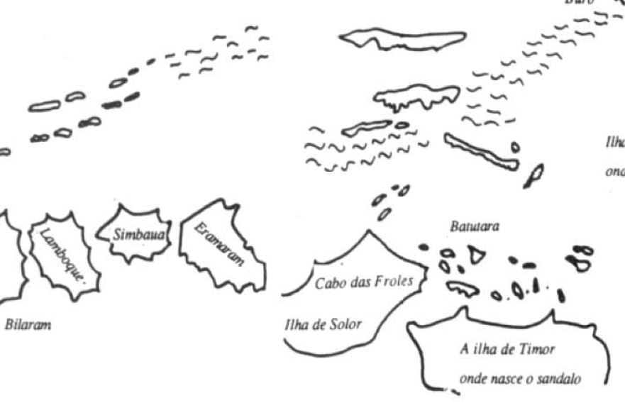
Detail from an assemblage of four sketches from Francisco Rodrigues’ unfinished Book and Atlas (Rodrigues 1511-1515, from Thomaz 1995, Plate III)
The Portuguese appear to have adopted the term old Solor (Solor velho) for the region around Ende and new Solor (Solor nova) for Sikka, Larantuka and Solor (Minutoli 1855 II, 366, cited by Metzner 1982, 67). In 1520 they established a trading post at Lamakera on the easternmost coast of Solor, a convenient staging post on the maritime route from the Spice Islands to Malacca. It is likely that this was already a regional entrepôt, perhaps with a local Muslim presence. By 1525 Solor had become a regular Portuguese haven for vessels involved in the exploitation of sandalwood on Timor, the coast of Timor lacking similar safe anchorages (Freycinet 1828, 528). Yet Solor was not an independent territory – it faced competing claims by both the Javanese and the Sultan of Ternate (Barnes 1987, 219).
When the Jesuit priest Baltasar Dias visited Solor in 1559 he reported that there was already a mosque and many Muslims, apparently overseen by several clerics, two who came from Calicut in Gujarat and three from Bengal (Jacobs 1974, 690-691, cited by Barnes 1987, 219). One of those from Calicut was producing gunpowder. Many Chinese also visited the island. Some 200 Portuguese sailors had wintered on Solor that year, waiting for the storms to subside. They had already made some Catholic converts.
Two years later, in 1561, Malacca dispatched three Dominican missionaries to establish a mission on Solor – Father Antonio da Cruz, Father Simao das Chagas, and Brother Francisco Alexio (Belo 2017). They erected a fort made from lontar palm wood at Lohayong, about 8km west of Lamakera. In 1563 a hostile Muslim Javanese fleet attempted to dislodge them from the island, burning their palisade to the ground. Fortunately, its occupants were rescued by a Portuguese galleon en route from Ternate to Malacca (Rouffaer 1923/24, 205f; Barnes 1987, 220).
In 1566 the Dominicans constructed a stonewalled fort, Forte de Nossa Senhora da Piedade, with five bastions defended by cannon (Barnes 1987, 209-210). It enclosed a church, a cloister and a well. To its west lay the village of the local chief (sang adipati) with its own church and 1,000 inhabitants, while to the east lay a second village with 2,000 inhabitants including Portuguese traders and their families, many mestizos, and foreign Christians. These so-called Black Portuguese increasingly dominated the profitable trade in sandalwood, beeswax and slaves taken from Timor Island. They eventually became known as Topasses, intermarrying with the Timorese ruling families and establishing their own powerful domains. The fort obtained its supplies from a variety of ports including Ende, Sikka and Pantar or Galiou (Tiele 1886, 89; Dietrich 1984, 319).
In 1575 a captain and 20 soldiers were installed on Solor to protect the Dominicans (Aritonang and Steenbrink 2008, 75). The mission extended its coverage, opening eight regional stations on Flores and one on Ende Island.
Yet on Solor the neighbouring Muslim community remained hostile, not helped by the tyrannical behaviour of the commander of the fort, António d’Andria, who even alienated some of the Dominican friars. He offended local adat, employed forced labour, took merchandise and services from local people without paying, imprisoned the sengaji of Lohayong, Dom Diogo, for dealing with local Muslims and attacked the Christian sengaji of Lamakera (Barnes 1987, 221). Matters came to a head in 1598, when the sengali of Lamakera led a revolt against d’Andria, burning down the fort, the church and some of the adjacent village. This was followed by eight months of anarchy and destruction, finally brought to an end by the arrival of a large Portuguese armada of ninety ships from Malacca, which completely destroyed the rebel village of Lamakera. Its Christian population of 2,000 immediately converted to Islam (Aritonang and Steenbrink 2008, 78).
In response, in 1602 a chieftain at Maumere on Flores persuaded the Karaeng or ruler of Talloq (Makassar) to despatch a fleet of 37 ships and three thousand men under the command of Dom João Juang to attack the Portuguese on both Solor and Ende Islands, along with their Christian allies at Sikka Natal (Abdurachman 2008, 74). By chance the fortress on Solor Island was at that time strongly manned by the crew of a galleon that had been stranded the previous year off the eastern tip of Java. Seeing that the fort could not be taken easily, Dom João sailed on to attack Sikka instead.
In 1603-1604, the Solor fort burned for the second time. Friar Simao Pacheco brought in a Chinese who covered the roofs of the church, bastions and houses with tile (Barnes 1987, 210).
Return to Top
Arrival of the Dutch
Earlier in 1568 the Protestant Dutch provinces, led by William of Orange, had begun their long struggle against Spanish Habsburg rule. After uniting in 1579, they declared independence from Spain in 1581. During the 1590s the United Provinces began to seek trading opportunities in the East Indies, bringing them into conflict with Habsburg Portugal, which had been subjugated by Spain in 1580. In 1602 the Dutch formed the powerful Verenigde Oost-Indische Compagnie or VOC, a quasi-governmental trading company that would fund exploratory voyages, establish trading agreements with local rulers and construct militarily bases. That same year 25 Dutch ships sailed for the East Indies (Loureiro 2005, 177). VOC policy was aimed at eliminating Portuguese power by attacking every one of their strongholds, working their way from east to west (de Roever 2005, 219). They began with an attack on Tidore in 1605, demolishing the Portuguese fort (Widjojo 2008, 22). The Dutch returned in 1607 and within a few years had established four forts on Ternate, one on Tidore and another on Halmahera.
Dutch interest in Solor was motivated by its desire to gain a stake in the profitable Timorese sandalwood trade. In early 1613 a Dutch fleet led by Appolonius Schotte, assisted by troops from Ternate, laid siege to the Portuguese fort on Solor for three months, their bombardment reducing the fort and the surrounding town to ruin. The Dutch timing was opportune – many of the Portuguese were away working on Timor. The defeated Portuguese, mainly mestizos, were treated leniently by Schotte and allowed to travel to Malacca with half of their possessions, although many settled in nearby Larantuka instead. The people of Larantuka were Demon who generally supported the Portuguese while opposing the Islamic Paji on Solor. The native Christians submitted to the Dutch.
Schotte described the fort as well located, close to the shore but on high ground with steep valleys on either side (Lach and van Kley 1998, 1459-1460). On the island there were three villages of new Christians, which included Pamakayo and Lewolein. Lamakera was Muslim.
Schotte appears to have promised Dutch protection in return for an exclusive trade agreement between the VOC and the leader of the Solor community, Kaichil Partani (or Pertawi), based at Menanga, whose father, Dom Diogo, had been killed by the Portuguese (Barnes 1987, 225). Part of the contract guaranteed religious freedom. By this time Solor had taken a leading role in an alliance with a few other coastal Muslim Paji states, forming a confederation known as the Solor Watan Lema (the five shores of Solor), consisting of Lohayong and Lamakera on Solor, Lamahala and Terong on Adonara and Labala on Lembata. For these villages, long hostile to the Portuguese, the arrival of the Dutch could not be more welcome. The Dutch provided protection against the proselytizing of the Portuguese Catholics and the influence of Makassar, which occasionally sent expeditions to Solor in order to collect taxes (Viola 2013, 101). However, the people of Solor claimed they were subject to the Sultan of Ternate not Makassar (Lach and van Kley 1998, 1460).
Van der Velde, the new commander of the renamed Fort Henricus, quickly restored it, constructing a new bastion on the west side (Tiele and Heeres 1886, 84). We are fortunate to have an engraving of the fortress as it supposedly was in 1613, thanks to Governor-General Pieter Both who sent five portraits of it to the VOC on 1 January 1614 (Coolhaas 1960, 26). One of them seems to be the basis of a later engraving published in 1646. It shows the Solor Strait, marked A, with the fort (D) and the north shore of Solor, the two entrances to the Solor Strait (B and C), and the south shore of Adonara with Ilé Boleng, depicted upside down.
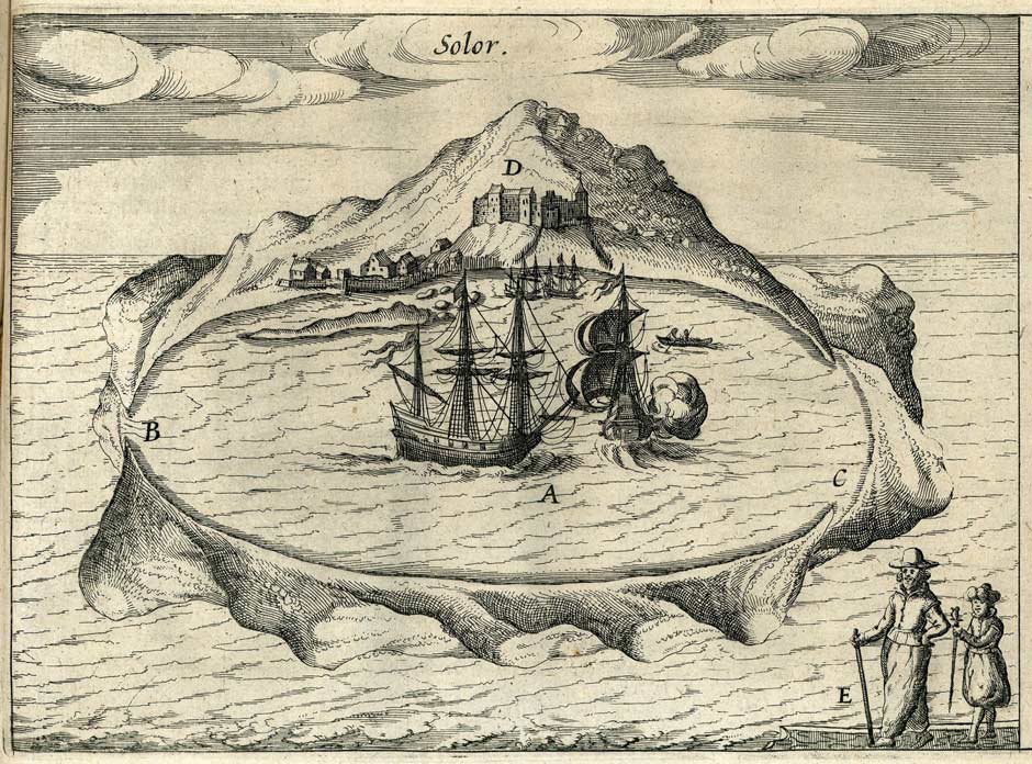
Above: Fort Henricus in about 1613. Isaac Commelin, 1646. Begin ende Voortgangh van de Vereenighde Nederlantsch Geoctroyeerde Oost-Indische Compagnie, vol. 4. Reproduced in Ludwig Johann Gottfried, 1655. Newe welt und Americanishe historien, page 483.
Below: A detail of the fort.

Dutch interest in Solor was part commercial and part strategic, providing a naval base for controlling the sandalwood trade out of Timor. Yet van der Velde saw the VOC restrictions on trade as a negative development and complained to the Governor-General that they threatened the future of this once thriving trade centre. Van der Velde’s command was short-lived – he was killed in a skirmish on Adonara in the summer of 1614. The next commander, Janszoon, did not last long either. At the end of 1615 he was ordered to abandon the fort and completely raze it, the VOC deciding that it was unprofitable and strategically unnecessary.
The Portuguese made several unsuccessful attempts to retake the fort and Kaichil Partani complained that the Dutch had broken their promise to defend he island. In 1618, J. P. Coen, the Governor-General of the East Indies agreed to defend the Solorese against the Portuguese and to reconstruct the fort, which he suggested should be square and hold 30 to 40 defenders. He also signed a new a contract that was identical to that agreed in 1613 and acknowledged that parts of the island belonged to the Sultan of Ternate. Crijn van Raemburch was installed as the fort’s new commander and successfully repulsed another Portuguese attack the following year (Barnes 1987, 228-229). In 1620 van Raemburch staged an attack on Larantuka but suffered heavy losses.
Van Raemburch was replaced by Jan Thomaszoon Dayman in 1622 who converted to Catholicism and deserted to Larantuka with his Solorese wife and family three years later. He in turn was superseded by Jan de Hornay, a drunkard and incompetent and untrustworthy leader. In 1627 Lohayong succeeded in repelling an attack by Lamahala on Adonara thanks to the intervention of the son of Kaicili Pertawi.
By now Dutch interest in Solor was fading fast, especially after the Dutch capture of Jakarta in 1619. In 1628 Coen sent Gregorius Corneliszoon to Solor to evacuate the fort and to raze it once again. When he arrived early the following year, the commander de Hornay had, like his predecessor, converted to Catholicism and fled to Larantuka. His son, António de Hornay, would go on to become an important leader of the Black Portuguese Topasses. In 1655 he became captain of a company of militiamen in Larantuka and later was appointed Capitao-mor de Timor, which made him the effective ruler of Timor (Aritonang and Steenbrink 2008, 89).
Having heard that the fort had been abandoned, the Portuguese Dominican Vicar-General Miguel Rangel sailed from Malacca and in 1630 succeeded in regaining the Lohayong fortress, assisted by Larantuka and Pamakayo. Despite opposition from Larantuka, he rebuilt the bulwark facing the sea that the Dutch had destroyed, and installed a garrison of 40 men armed with 15 cannons.
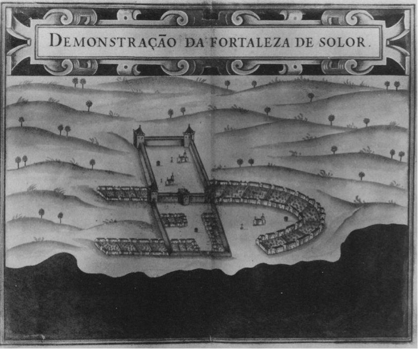
Above: Solor Fort. Aquarelle by Pedro Barreto de Resende (1635), Bibliotheque Nationale, Paris. Below: The Portuguese Fortazela de Solor Island
(in Teodoro de Matos, Timor Português, 1515-1769).
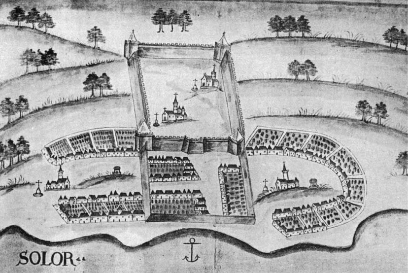
Rangel left us a positive, probably exaggerated, description of Solor Island (Lach and van Kley 1998, 1457-1461). The fort was beautiful and strong with five bulwarks, three on the coast and two inland. It was surrounded by beautiful gardens, a town with as many as 5,000 inhabitants and three beautiful churches. There was an abundance of hill rice for the fort, and in the absence of vegetables, yams were an important staple for the local people. Fruit was plentiful. Meat was available from sheep, goats, deer, pigs and buffalos and there was a large variety of fish. There was ample stone and firewood. The island exported Timorese sandalwood, wax, turtles, slaves, cattle and cinnamon from Ende. It imported gold, silver, ivory, iron and finished cloth, especially silk! However, Rangel thought the people of Solor were lazy and had no interest in farming or fishing. “They are wholly devoted to war, arms, vanity, honour and recreation”.
Rangel’s occupation was brief. In 1636 a Dutch fleet under the leadership of Jan Tombergen bombarded the Lohayong fortress, an act that led to the Portuguese garrison withdrawing to Larantuka for safety. Unable to man it themselves, the Dutch left the fort empty.
After the Dutch dislodged the Portuguese from Malacca in 1641, many had resettled in Makassar, Ende and to a lesser extent Larantuka. The VOC increased its efforts to bring Flores and the neighbouring islands under its control. In 1646 fearing that the Portuguese might reoccupy Solor to create a new base in the Indies, the VOC dispatched major Willem van der Beek to Solor with a detachment of troops with instructions to re-garrison Fort Henricus, establish a new treaty with the local chieftain and persuade him to move to Lohayong. Lieutenant Hendrik van Oldenburgh was placed in command of the fort with 34 troops.
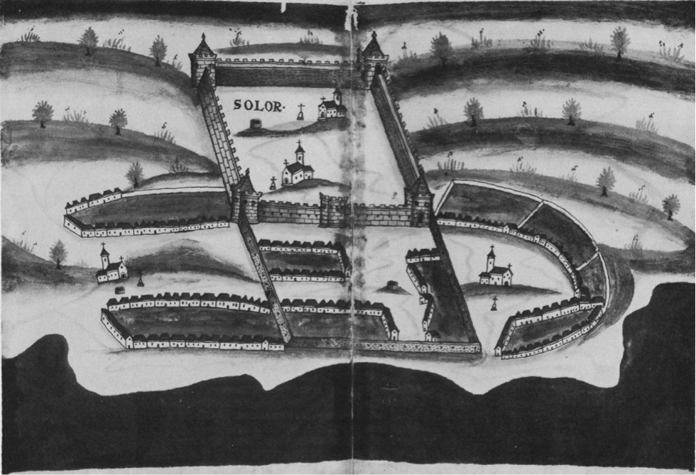
Another version of the Portuguese Forte de Nossa Senhora da Piedade at Loyahong in 1646
(Pedro Barreto de Re, British Museum, Sloan Collection no. 197)
Kaicili Pertawi had died in 1645, and had been replaced by his widow Nyai Cili Pertawi, who was persuaded to sign a renewed version of the 1618 treaty, stipulating that all goods earmarked for export, including slaves, had to be sold to the company (Heeres 1907, 460-463).
Commander van Oldenburgh died after a long illness in January 1648 and was replaced by the merchant Hendrik ter Horst. A few days later on 2 February, Solor Island was hit by the first of two powerful earthquakes, bringing down the curtain walls of Fort Henricus. Van der Beek witnessed the earthquake from his galleon, den Wolff. Attempts were being made to patch up the old fort when, on 24 February, there was a second earthquake, which split the remaining walls.
Ter Horst was left in charge of the ruins supported by 44 troops. Despite the damage, Nyai Cili Pertawi agreed to move into the fortress from her base at Menanga. Although she was referred to as the Queen of Solor, she was only the chief of eastern Solor but did play a leading role in the Solor Watan Lema confederation.
Return to Top
Publication
This webpage was published on 8 April 2026.